Kayla Zhu
2024-10-05 15:26:21
www.visualcapitalist.com
![]() See this visualization first on the Voronoi app.
See this visualization first on the Voronoi app.
Ranking the Dirtiest Cities in the U.S.
This was originally posted on our Voronoi app. Download the app for free on iOS or Android and discover incredible data-driven charts from a variety of trusted sources.
From poor air quality to the presence of unwanted litter and pests, living in dirty and polluted cities can have detrimental effects on quality of life.
Air pollution is dangerous to our lung health, contributing to respiratory diseases and exacerbating conditions like asthma and bronchitis, while uncollected trash and rampant litter can attract vectors for diseases and viruses.
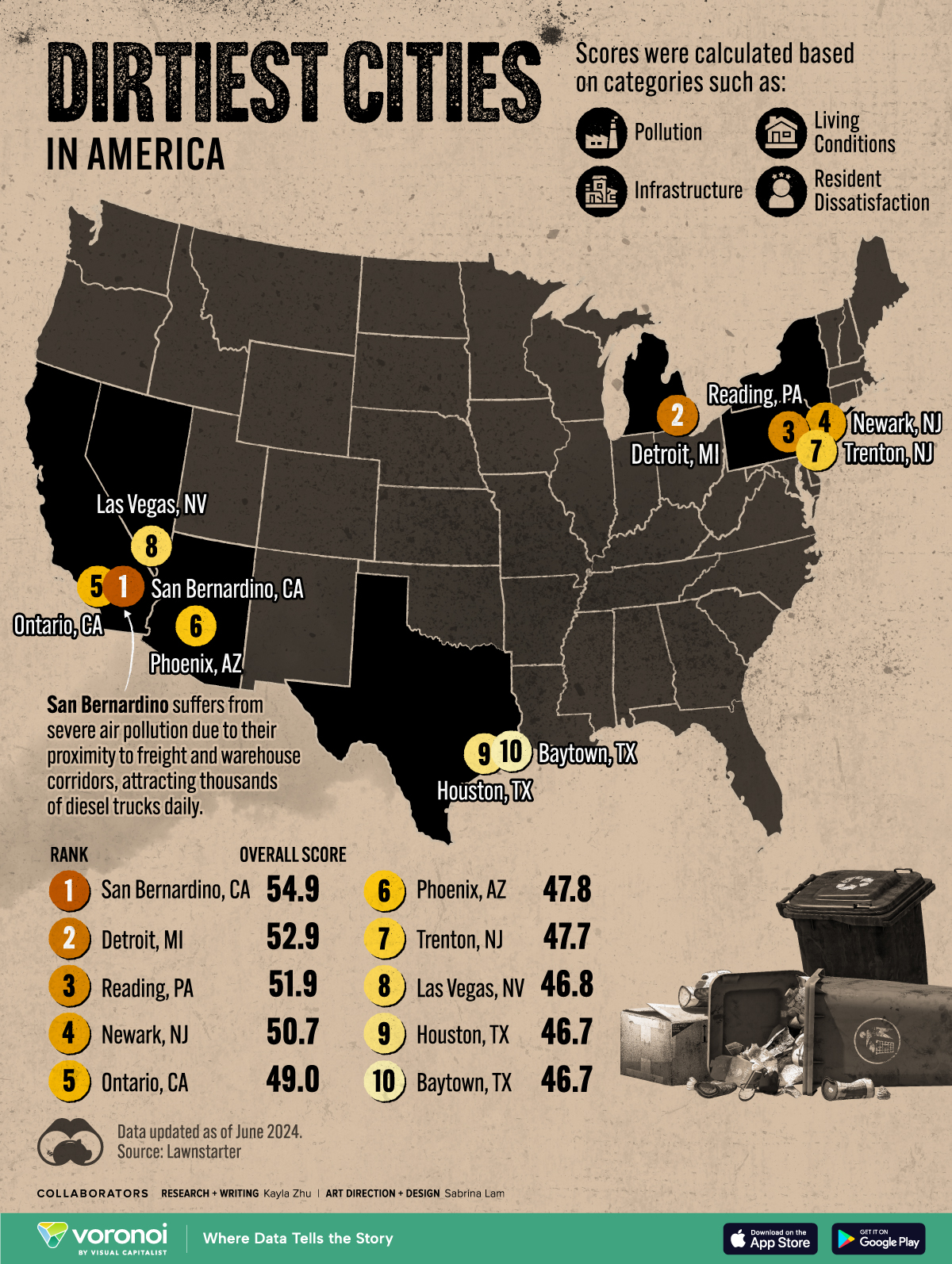
This map visualizes the top 10 dirtiest cities in the U.S. as ranked by a proprietary ranking from Lawnstarter with data as of June 2024.
In the ranking, over 300 major cities are scored on four main categories of pollution, infrastructure, living conditions, and resident dissatisfaction. Some metrics included in the score calculations include: air quality index, greenhouse gas emissions per capita, water quality violations, quantity of waste in landfills per capita, population density, and share of overcrowded rooms.
San Bernardino Ranked Dirtiest City in America
San Bernardino County in California is home to two of the top 10 dirtiest cities in the U.S., including first-ranked San Bernardino city and fifth-ranked city Ontario.
California, Texas, and New Jersey were each tied with two cities ranking in the top 10.
| Rank | City | State | Overall Dirtiness Score |
|---|---|---|---|
| 1 | San Bernardino | California | 54.90 |
| 2 | Detroit | Michigan | 52.89 |
| 3 | Reading | Pennsylvania | 51.85 |
| 4 | Newark | New Jersey | 50.66 |
| 5 | Ontario | California | 49.02 |
| 6 | Phoenix | Arizona | 47.82 |
| 7 | Trenton | New Jersey | 47.71 |
| 8 | Las Vegas | Nevada | 46.82 |
| 9 | Houston | Texas | 46.73 |
| 10 | Baytown | Texas | 46.67 |
San Bernardino County consistently ranks first in the country for the worst ozone and particulate pollution.
The county is a major shipping hub, and home to multiple freight and warehouse corridors. Located in the Inland Empire, adjacent to coastal Southern California, it has about 1 billion square feet of warehouse space.
Heavy diesel truck traffic passes through its roadways daily, heading to the region’s 9,500 warehouses.
Diesel trucks can emit dangerous levels of nitrogen oxide and particular matter, causing a slew of serious health outcomes like chronic obstructive pulmonary disease and cancer. Doctors have termed these areas as “diesel-death zones.”
Learn More on the Voronoi App 
If you want to learn more about the countries with the worst air pollution in the world, check out this graphic which maps the top 20.
The post Mapped: The 10 Dirtiest Cities in America appeared first on Visual Capitalist.
Support Techcratic
If you find value in Techcratic’s insights and articles, consider supporting us with Bitcoin. Your support helps me, as a solo operator, continue delivering high-quality content while managing all the technical aspects, from server maintenance to blog writing, future updates, and improvements. Support Innovation! Thank you.
Bitcoin Address:
bc1qlszw7elx2qahjwvaryh0tkgg8y68enw30gpvge
Please verify this address before sending funds.
Bitcoin QR Code
Simply scan the QR code below to support Techcratic.

Please read the Privacy and Security Disclaimer on how Techcratic handles your support.
Disclaimer: As an Amazon Associate, Techcratic may earn from qualifying purchases.


![Pioneer [Blu-ray]](https://techcratic.com/wp-content/uploads/2024/11/81EmJG9mivL._SL1500_-360x180.jpg)


![Alien Stickers [200pcs] UFO Stickers for Teen, Vinyl Water Bottles Waterproof Stickers for Laptop Guitar Scrapbook Skateboard Stickers](https://techcratic.com/wp-content/uploads/2024/11/91DUuGusXeL._AC_SL1500_-360x180.jpg)


